


NavLink
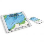
“NavLink is a low cost app designed for use with an iPhone or iPad. It transforms your iPad into a full function chart plotter with detailed electronic charts and an overlay of your boat’s position, track and heading.”
Description
KEY FEATURES
NavLink is a low cost marine navigation app designed for use with an iPhone or iPad. It transforms your iPad into a full function chart plotter with detailed electronic charts and an overlay of your boat’s position, track and heading. It’s purchased through the Apple app store and includes detailed Admiralty UKHO charts covering the whole of the UK & Eire. Additional USA (S57 NOAA), French, Benelux, German and Danish charts can be added via an In-App Purchase. The NOAA S57 charts cover the whole of the US.
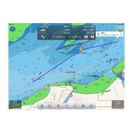
The app presents charts north up or course up and the user can create and edit routes and waypoints using a simple touch screen interface. Real time navigation shows your current position, track, course, speed, ETA, VMG, bearing and distance to next waypoint. There’s a simple A-B chart ruler too and you can tap on an object such as a buoy or nav-aid and get a pop up data window of its characteristics. Can download current weather data and local conditions from weather buoys (will require an internet connection). This is great for last minute local weather before setting off on a voyage. The S57 Admiralty UKHO charts are vector based so the user can layer and enable/ disable data allowing de-cluttering of charts as appropriate.
NavLink also helps with your watch keeping and lookouts. In HorizonView mode, you can use the camera on the iPhone/iPad to scan the horizon. You’ll get an overlay on the camera screen of nav-aids, AIS targets and waypoints which serves as a great visualisation aid.
SPECIFICATIONS
- Supports Digital Yacht WLN10, iNavHub, NavLink and iAIS products. can also see the boat’s NMEA data on iPad or iPhone when using this app with these devices
- North up and course up displays
- Real time tracking and track export to Google maps
- AIS overlay when connected to compatible AIS system
- Waypoints and routes with full route editing and planning function
- Position, COG, SOG, VMG, bearing, distance and ETA displays
- Configurable layers: Buoys, lights, depths contours, spot depths, wrecks, traffic zones, anchorages
- HorizonView – Overlays nav-aid and targets onto iPad/Phone camera display for easy real time viewing and location
- Automatic free chart updates included for 1 year
- Weather buoy data
- A-B chart ruler for quick and easy bearing and distance measurement
- All UK & Ireland charts are included in the price
- Additional French, Benelux, German and Danish charts available for In-App purchase
- Tide and sunrise/set displays
- US version also available (NavLink US)
Manual and Downloads
